

Pre-Incident Planning for the Aquatic Rescue
By: Bob Shields
Is your department ready to handle a multi-victim boating accident, or a missing swimmer, or a flood or ice rescue incident? These are some of the questions that need to be answered to ensure a safe and effective response to any aquatic emergency. Most departments pre-plan large buildings or develop emergency response plans for large gatherings. Departments need to recognize the need to pre-plan for bodies of water as well. Over 70% of the earth is covered by water. This means that there is water somewhere in a department’s response area and the potential for an incident to occur.
Planning for each type of incident
According to NFPA 1670, the Authority Having Jurisdiction (AHJ) needs to identify hazards and risks that put people in danger in and around the water. Pre-planning allows departments to recognize hazards and risks and develop a plan for each body of water within the response area. It can also help determine what resources will be needed based on the type of incidents, such as surface water, submerged victim(s), ice, swiftwater, submerged vehicle, or boating accidents.
How to pre-plan
An important consideration in the development of the pre-plan is the history of the site. What is it used for? Have there been past incidents and if so, what type? Are there attractive nuisances such as cliffs, bridges, or other activities that put people at risk?
After considering the history of the site, the pre-plan should contain the following:
- Name(s) of the body of water
- Access points for boats and personnel
- GPS coordinates
- Site description
- Known hazards including currents
- Staging areas
- Specifics relating to underwater searches
Document Everything
The first thing that should be considered in developing a pre-plan is to clearly identify the body of water. Bodies of water could have different names based on what residents call it and what is identified by maps or local/state agencies. As an example, a local swimming hole has been called “Coomer’s Beach” for years but is identified by the town as Marion Irons beach. Both should be listed under identification of the body of water.
Access points such as boat ramps, beaches, low-level embankments, and docks should be identified and their locations noted. It is important to know this since companies are dispatched to an address where a boat may not be able to be launched. If the boat ramp two miles away was identified, then responders can immediately go there and launch the boat and make their way to the incident area.
Noting GPS coordinates and providing specific addresses will aid in decreasing response times and increasing the potential for a successful rescue. Landmarks such as dams and bridges can also help identify specific areas on a body of water. These will also aid in sectioning off a large lake or river. Each section can then contain its own plan.
What activities occur?
A description of the site includes what events or activities are common at that site. Are there camps or recreational areas? Are they protected by lifeguards? If dealing with static bodies of water such as lakes, ponds, or quarries, depths should be determined. A resource for this might be available through local or state environmental resource departments. A visit to the site can provide abundant information. Local divers and dive shops, residents, and state agencies can also be resources.
When dealing with oceans, include a general time frame of when tides occur. Look to local lifeguards and residents to determine what currents are prevalent and if there have been issues with rip currents. If there are rivers or streams, the United States Geological Survey provides streamflow data that can show real-time changes in currents and river levels. Local river guides or kayak/canoe rental companies can alsoprovide information about the river.
Identifying staging areas on the plan will assist the IC and Staging Officer to identify what resources are at the scene including what manpower is available. Larger waterways may need multiple designated staging areas depending on where the incident is located. In moving water incidents, staging may include providing downstream rescue teams staged at specific locations to prepare for the rescue of a victim. These resources can also be utilized as a downstream backup once a rescue commences upstream.
Knowing the underwater topography and features will aid divers in determining search patterns as well as developing an emergency action plan in the event a diver needs assistance. Conducting training dives at local bodies of water can greatly assist in developing action plans for future incidents. It can also make divers more comfortable in the environment, especially if there are hazards such as heavy weeds, large objects, currents, or limited visibility. Creating an underwater map and adding it to the pre-plan will be of great assistance when an incident arises.
Remember, pre-incident planning can not only assist responders at the time of an incident but will make the rescue run more smoothly and safely overall.
 https://www.tdisdi.com/wp-content/uploads/2024/02/ERDI-Ambassadr.jpg
628
1200
Rachel Pryke
/wp-content/uploads/2021/10/header-web-live.png
Rachel Pryke2024-02-01 10:04:292024-03-26 16:07:01Introducing the 2024 ERDI Ambassadors
https://www.tdisdi.com/wp-content/uploads/2024/02/ERDI-Ambassadr.jpg
628
1200
Rachel Pryke
/wp-content/uploads/2021/10/header-web-live.png
Rachel Pryke2024-02-01 10:04:292024-03-26 16:07:01Introducing the 2024 ERDI Ambassadors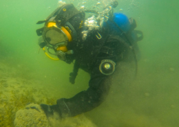 https://www.tdisdi.com/wp-content/uploads/2024/01/Wheretosearch_Banner.jpg
628
1200
Rachel Pryke
/wp-content/uploads/2021/10/header-web-live.png
Rachel Pryke2024-01-17 15:07:522024-03-13 16:44:36Navigating the Depths: Search Theory in Public Safety Diving
https://www.tdisdi.com/wp-content/uploads/2024/01/Wheretosearch_Banner.jpg
628
1200
Rachel Pryke
/wp-content/uploads/2021/10/header-web-live.png
Rachel Pryke2024-01-17 15:07:522024-03-13 16:44:36Navigating the Depths: Search Theory in Public Safety Diving Y. ZIN
https://www.tdisdi.com/wp-content/uploads/2023/11/Surface-IceRescue.png
628
1200
Rachel Pryke
/wp-content/uploads/2021/10/header-web-live.png
Rachel Pryke2023-11-13 16:38:332024-03-26 16:09:39The 20:10:1 Rule – A Safer Approach to Surface Ice Rescue
Y. ZIN
https://www.tdisdi.com/wp-content/uploads/2023/11/Surface-IceRescue.png
628
1200
Rachel Pryke
/wp-content/uploads/2021/10/header-web-live.png
Rachel Pryke2023-11-13 16:38:332024-03-26 16:09:39The 20:10:1 Rule – A Safer Approach to Surface Ice Rescue https://www.tdisdi.com/wp-content/uploads/2023/09/dive-team-investigation.jpg
628
1200
William Drumm
/wp-content/uploads/2021/10/header-web-live.png
William Drumm2023-09-20 16:41:392023-09-20 17:26:09Unearthing Evidence: How a Public Safety Dive Team Transformed an Investigation
https://www.tdisdi.com/wp-content/uploads/2023/09/dive-team-investigation.jpg
628
1200
William Drumm
/wp-content/uploads/2021/10/header-web-live.png
William Drumm2023-09-20 16:41:392023-09-20 17:26:09Unearthing Evidence: How a Public Safety Dive Team Transformed an Investigation https://www.tdisdi.com/wp-content/uploads/2022/11/erdi-ambassadors.jpg
628
1200
William Drumm
/wp-content/uploads/2021/10/header-web-live.png
William Drumm2022-11-28 11:40:402022-11-28 11:40:402023 ERDI Ambassadors
https://www.tdisdi.com/wp-content/uploads/2022/11/erdi-ambassadors.jpg
628
1200
William Drumm
/wp-content/uploads/2021/10/header-web-live.png
William Drumm2022-11-28 11:40:402022-11-28 11:40:402023 ERDI Ambassadors https://www.tdisdi.com/wp-content/uploads/2022/10/tender-helps-psd-diver-with-gear.jpg
628
1200
William Drumm
/wp-content/uploads/2021/10/header-web-live.png
William Drumm2022-10-20 16:18:392022-10-25 12:12:29PSD Tenders – The Unsung Heros
https://www.tdisdi.com/wp-content/uploads/2022/10/tender-helps-psd-diver-with-gear.jpg
628
1200
William Drumm
/wp-content/uploads/2021/10/header-web-live.png
William Drumm2022-10-20 16:18:392022-10-25 12:12:29PSD Tenders – The Unsung Heros https://www.tdisdi.com/wp-content/uploads/2022/04/Throw-Bags_1280x720.jpg
675
1200
Allison Van Sickle
/wp-content/uploads/2021/10/header-web-live.png
Allison Van Sickle2022-04-20 12:36:402022-04-28 10:18:44The Selection and Use of Water Rescue Throw Bags
https://www.tdisdi.com/wp-content/uploads/2022/04/Throw-Bags_1280x720.jpg
675
1200
Allison Van Sickle
/wp-content/uploads/2021/10/header-web-live.png
Allison Van Sickle2022-04-20 12:36:402022-04-28 10:18:44The Selection and Use of Water Rescue Throw Bags https://www.tdisdi.com/wp-content/uploads/2021/10/Copy-of-ERDI-Article-Headers.jpg
628
1200
James Councill
/wp-content/uploads/2021/10/header-web-live.png
James Councill2021-10-20 18:59:092021-10-20 18:59:09My Way is Better Than Your Way
https://www.tdisdi.com/wp-content/uploads/2021/10/Copy-of-ERDI-Article-Headers.jpg
628
1200
James Councill
/wp-content/uploads/2021/10/header-web-live.png
James Councill2021-10-20 18:59:092021-10-20 18:59:09My Way is Better Than Your Way
Skriv en kommentar
Vil du deltage i diskussionen ?Du er velkommen til at bidrage !